Supported by



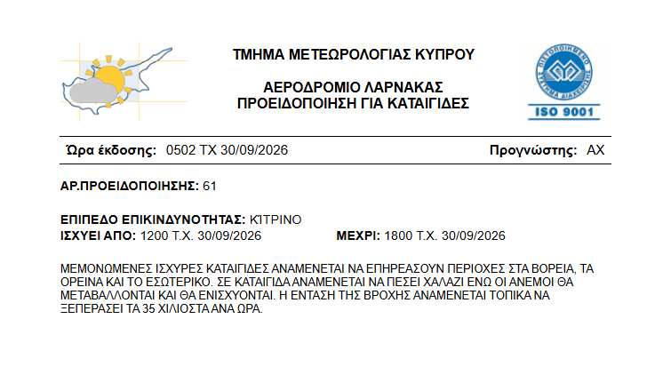
Thunderstorms in Cyprus could be severe in places today. The Meteorological Department has issued a yellow warning for Wednesday, September 30, from 12:00 PM to 6:00 PM. The northern part of the island, the mountains, and the interior are most at risk. Hail is possible during thunderstorms, and rainfall intensity could reach locally 35-45 mm per hour.
Unstable weather will continue in the coming days. Rainfall and isolated thunderstorms are forecast until Saturday, with Friday potentially seeing particularly intense or prolonged showers. Temperatures will gradually drop below typical temperatures for this time of year.
The warning applies primarily to the north, mountainous areas, and interior of the island. Meteorologists predict isolated severe storms, the course and intensity of which may change rapidly.
This doesn't mean, however, that other regions will remain completely dry. Wednesday's forecast also includes the possibility of precipitation in the east. Localized rainfall is possible along the coast, and a single thunderstorm in the southwest.
The greatest development of cloud cover and intensification of precipitation is expected in the afternoon.
Hours: 12:00–18:00, local time
Areas: north, mountains and interior of the island
Threats: severe storms, heavy rain and possible hail
Rainfall intensity: locally 35–45 mm per hour
The value provided describes the rainfall intensity during the event, not the rainfall total for the entire day and island. Storms will be localized, so conditions may vary significantly even between nearby towns.
On Wednesday the temperature will reach approximately 30°C inland, 28°C on the coast and 18°C in the highest parts of the mountains.
The wind will blow mainly from the southwest and northwest, initially at force 3-4 on the Beaufort scale. It may gradually increase to force 4-5 along the coast. The sea will be slightly rough.
The evening and overnight will remain mostly cloudy. Isolated showers are possible along the coast, with a possible thunderstorm in the west and north. Temperatures will drop to around 19°C inland and on the coast, and 8°C high in the mountains.
The weather will remain mostly cloudy on Thursday, October 1, Friday, October 2, and Saturday, October 3. Isolated showers or thunderstorms may occur along the coast in the morning.
Later, especially in the afternoon, the phenomena will affect other areas and may intensify. Hail is also forecast during the storms.
On Friday, rainfall and storms may be intense or last longer. This is important information for people planning trips, outdoor activities or mountain travel.
Temperatures will gradually decline through Friday. No significant change is expected on Saturday, with values remaining below seasonal norms.
During heavy rain, visibility on roads can deteriorate dramatically. Drivers should reduce speed, increase following distances, and avoid driving through water whose depth they cannot estimate.
People in the mountains or outdoors should react to an approaching storm well in advance. Avoid seeking shelter under a lone tree or remaining in water during lightning.
Today's warning is valid until 6:00 PM. The forecast for the coming days does not automatically mean an extension of the alert – any subsequent warnings will be issued separately.
Sources: Department of Meteorology, Philenews, Cyprus Mail